Margherita Peak is now technical. Knowledge of ropes, crampons, ascenders, figure-8s for belay, and use of an ice axe is advised. Ice sections are as steep as 60% and conditions change quickly due to climate change and the melting glacier. All our guides are trained in ice climbing and rescue.
They can guide climbers with little experience, but you must be prepared to learn on the way. You should know how to fit crampons, tie basic knots, and use ascenders and figure-8s. Mt Baker and Mt Speke are also technical. We advise clients to bring their own crampons because the mix of hard ice and rocks wears them down quickly.
Note: It is possible to climb in seven days, and some clients prefer this. However, climbing more than 500m a day increases the risk of altitude sickness, pulmonary edema, or cerebral edema, all of which are dangerous. It is safer to take more days. Previous climbs do not help unless done within two weeks, as acclimatization depends on increased red blood cells.
We can offer seven-day treks, but we recommend the eight-day trek as the safer option. Altitude affects people differently, and even the very fit can suffer. The cost of both treks is the same, to discourage choosing the shorter option only to save money.
Note: Trekking in the Rwenzori Mountains is much harder than Kilimanjaro or Mt Kenya. You should be fit. The eight-day trek suits most people of average fitness. Some may complete it in seven days, but this requires high fitness and is not recommended for large groups, as often one person cannot keep the pace.
The trek begins at Trekkers Hostel in Kyanjuki, Kilembe, 1,450m above sea level and 12km from Kasese town. It is best to start by 9am, though you may leave as late as 11am. You walk 2.2km to the UWA ranger post at 1,727m in about one hour. Here you pay the entrance fee and receive a briefing on park rules. Guides usually brief clients the evening before the trek.
7-Day Rwenzori Tour Highlights
- Day 1: Hike to Kalalama Camp (3,134m)
- Day 2: Hike to Bugata Camp (4,100m)
- Day 3: Hike to Hunwick’s Camp (3,974m)
- Day 4: Hike to Margherita Camp (4,485m)
- Day 5: Summit Margherita Peak (5,109m)
- Day 6: Descend to Kiharo Camp (3,640m)
- Day 7: Descend to Basecamp (1,450m)
Detailed 7-Day Rwenzori Tour Itinerary
Day 1: Hike to Kalalama Camp (3,134m)
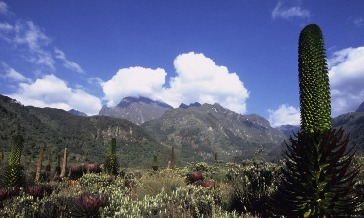
The trail starts through Afro-Montane forest. You may see blue monkeys, groups of colobus, or hear chimpanzees. Rare L’Hoest monkeys may also appear. The forest is full of trees, bamboo, and shrubs. You then enter the bamboo zone, which is steep with many steps. In the wet season it can be muddy and slippery. The climb continues to Kalalama Camp (3,147m), set in the Heather-Rapanea Zone, home to tall heather trees and the Rwenzori turaco with its crimson wings.
Day 2: Hike to Bugata Camp (4,100m)
After breakfast, bypass Mutinda Camp and continue to Bugata Camp. The trail climbs ridges, crosses streams, and passes waterfalls under giant heather trees covered in moss and lichen. The valley is often misty and full of flowers.
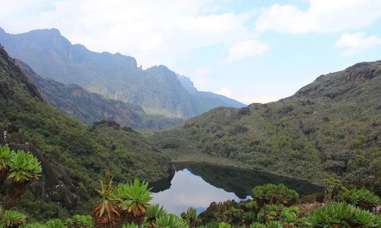
The path is boggy in parts, but boardwalks help. You cross Mutinda Valley with tussock grass, everlasting flowers, and giant lobelias, then climb steeply into Namusangi Valley (3,840m) with waterfalls and views of Mutinda Peaks. The trail continues with ups and downs to Bugata Camp (4,062m), high above Bugata Lake with views of Lake Kopello, Weismann’s Peak, and smaller lakes. The area is rich in alpine plants and home to the red forest duiker, found only in the Rwenzoris.
Bugata Camp has solar lights, good toilets, and bathrooms. Warm water can be prepared for washing. A helicopter pad is also available, though rescue flights in Uganda are costly, so insurance is required.
Day 3: Hike to Hunwick’s Camp (3,974m)
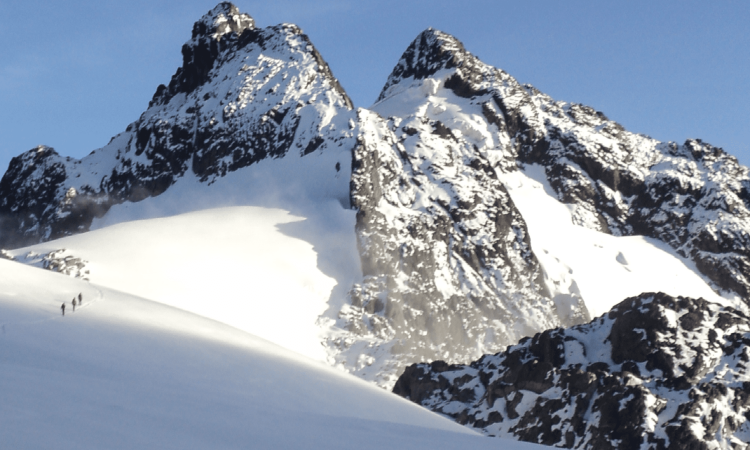
Climb towards Bamwanjarra Pass (4,450m). On clear days you can see the three main peaks. The trail passes bogs, moss, lobelias, and groundsel. Malachite sunbirds are often seen here. After a few steep climbs, you reach Hunwick’s Camp, set above a deep valley with views of Mt Stanley, Mt Baker, Weismann’s Peak, and McConnell’s Prong.
Day 4: Hike to Margherita Camp (4,485m)
From Hunwick’s, descend across the valley floor to Lake Kitandara. From there, climb Scott Elliott’s Pass and continue to Margherita Camp (4,485m), sheltered among large rocks. This is the site where the Duke of Abruzzi camped in 1906 before climbing Margherita Peak.
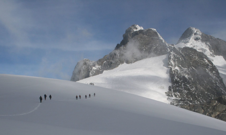
Day 5: Summit Margherita Peak (5,109m)
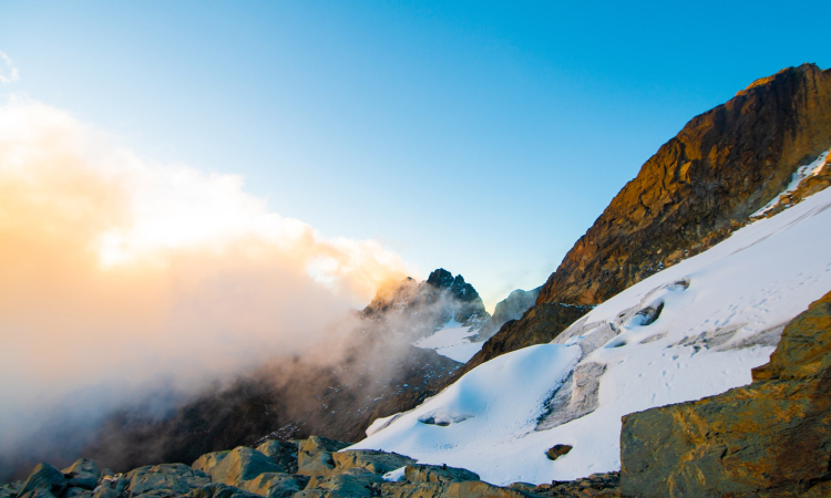
Wake at 2am, eat breakfast, and start the climb at 2:30am. Early starts are vital because clouds and snow often close in by early afternoon. Heavy snowstorms have even occurred in dry months, delaying groups until late at night.
A strict turnaround time of 10am is enforced. If you do not reach the peak by then, you must descend for safety. The glacier is steeper now, with ice slopes over 60% and hidden caves from melting ice. Guides will show the safest route.
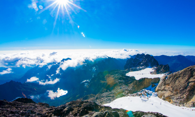
For less experienced climbers, there is an option to stay on Stanley Glacier and climb a rocky outcrop near Alexandra Peak for wide views over Congo and the mountains.
After summiting, descend directly to Hunwick’s Camp (3,874m).
Day 6: Descend to Kiharo Camp (3,640m)
Distance: 11km. Time: 4–7 hours.
From Hunwick’s, climb towards McConnell’s Prong and Oliver’s Pass (4,505m), with views of the main peaks. From there, the trail passes below Weismann’s Peak to the Nyamwamba River. Climbers may choose to summit Weismann’s Peak (4,620m) at extra cost.
Descend through valleys to Kiharo Camp, set in a deep gorge with cliffs and dense vegetation. Along the way, you pass ridges pushed up long ago by glaciers.
Day 7: Descend to Basecamp (1,450m)
Distance: 12.2km to the park gate, plus 2.8km to Trekkers Hostel. Time: 5–8 hours.
The Nyamwamba Valley trail is downhill with rivers, waterfalls, moss-covered rocks, and forests. It is one of the most rewarding sections of the Rwenzori. The path took six years to open. Explorer McConnell tried in 1937 but failed. Today, trekkers can complete the route he could not.
A few kilometers from Kiharo Camp, the path follows the river. You may see duikers feeding in clearings. Some sections allow walking along the river on rocks, though farther down it becomes too steep with waterfalls. Here the trail shifts to a ridge to bypass before rejoining the river at a rock shelter. After a short climb, it descends again to the river, avoiding more impassable waterfalls.
The forest here is rich in birdlife, primates, duikers, and hyrax. It makes a memorable ending to the trek.